Free Camping on Bike Trips & Other Advanced Trailforks Features
Many riders have heard about Trailforks by now and often think of it as the trail map app on your phone. But Trailforks is much more than just an app. One of the founding goals was to build a trail management system with features to empower local trail associations with data, planning & advocacy tools.
Trailforks has a large list of tools that have been created with these goals in mind, including many related to our robust trail reporting or ride log trail usage statistics systems. But here are 5 lesser-known advanced features.
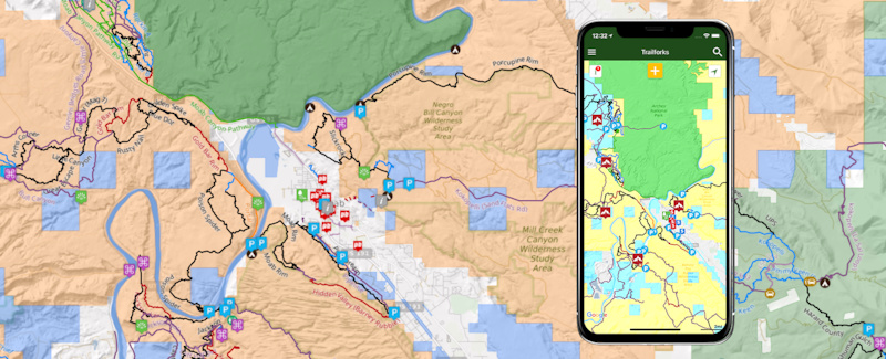
Land Owner Overlays
Working with Land Managers is always the first step to any trail work or maintenance, but it can sometimes be hard to understand where those boundaries are. Trailforks makes that easy. Whether you're in the field on the app or at home on the website, you can toggle on the Land Manager boundaries. Some of the Land Managers included are: the Forest Service, BLM, National Parks, Military, Indigenous Areas and any Congressional designated Wilderness Areas.
Tip: Want to camp for free? Trailforks now shows you exactly where the BLM land is.
BLM – Bureau of Land Management. Dispersed camping is allowed on most BLM land for up to 14 days. Even if land is leased or has mining claims, you may camp there unless posted otherwise by BLM management.
 | Recently I was on a trip near Joshua Tree Park in California and all the spots in the park were full. I pulled out the Trailforks App, turned on land owner overlay, and followed a dirt road on BLM land to an amazing mountain top camping spot, within a mile of the park boundary. Amazing! |
Heatmap Past/Current
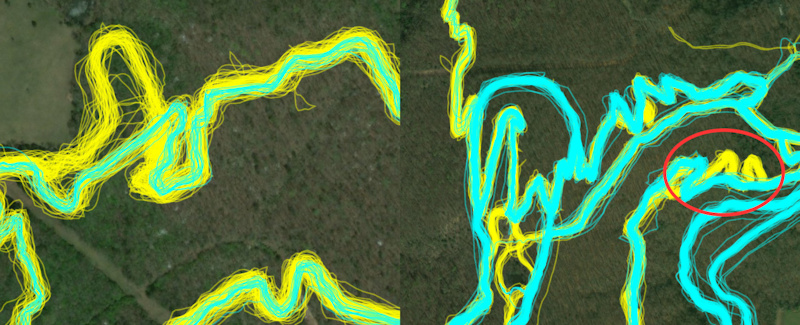
Notice in this photo marked in red shows that past tracks (yellow) follow switch backs, but all more current tracks (cyan) are now re-routed and running straight.
Many are familiar with the Trailforks heatmap and how it can be used to edit trail GPS tracks through its "ride lines" view. But we've been working hard at improving this feature. While editing a trail, you now have the option to view the historic ride lines (yellow) and the ride lines from the most current 6 months (cyan). This displays any new trends for riders as well as any new reroutes on older trails.
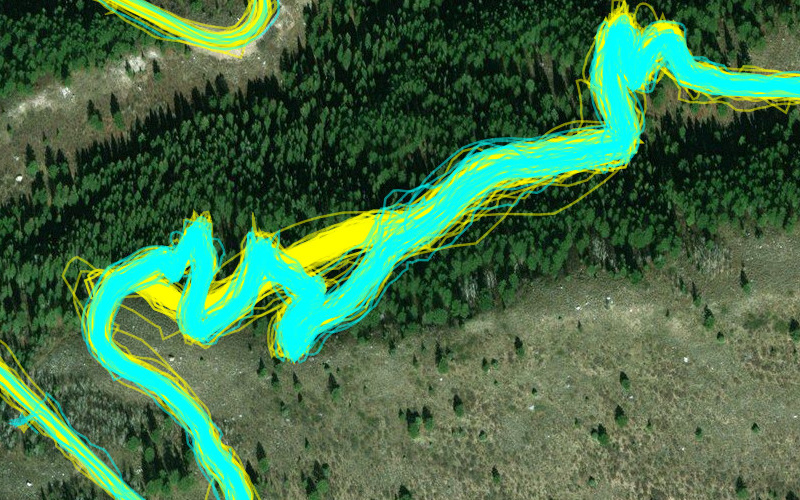
Example of an awesome reroute put in to fix that brutal climb at the start of Mill Creek. A favorite both up and down, now provides a much better climbing experience to access "The Ghee"
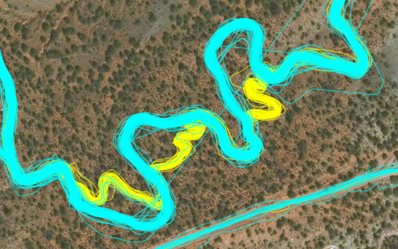
This is Wire Mesa where Jake Weber did some reroutes to open sight lines and widen some tight corners to create better flow. Thanks Jake!
Using the ride lines, you can edit trails' GPS tracks to be more accurate and trace where people actually ride.
Detect the following conditions easily:
• Trail re-routes
• New trails
• Old unused trails
• Improve trail GPS accuracy
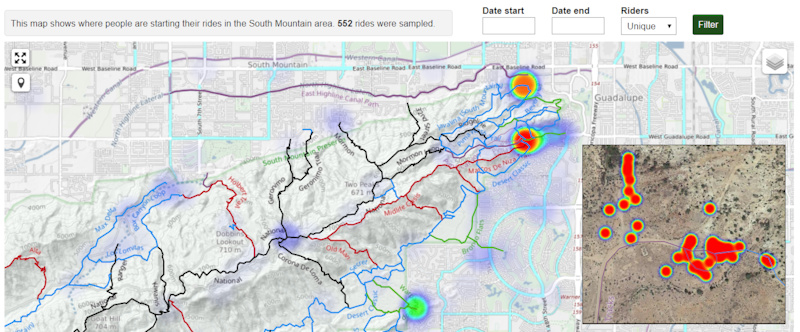
Ride Start Heatmap
Trailforks has created a new heatmap that only shows the spot where riders have hit record on their GPS or Smartphone. The Ride Start Heatmap is great to see which parking lots are being used. Using the heatmap. you can identify potential conflict areas early on, perhaps identifying the need for new parking lots, trailheads or climbing trails. For extra privacy reasons, we do not make this feature publicly available. You will need to be given admin permissions for your region to access it via the admin page.
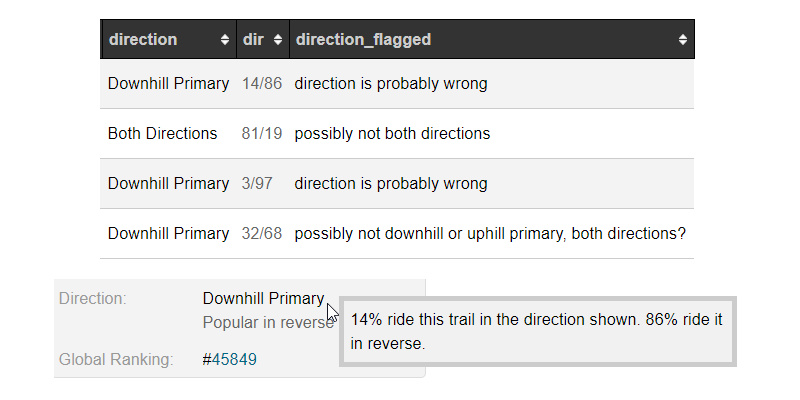
Auto-direction
Using the user-contributed ride logs, Trailforks can now display the preferred direction of a trail. This is great to see how riders are using your network, and help trail organizations better understand which trails are used for climbing and which are used for descending.
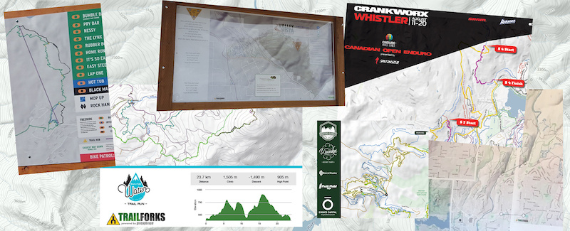
Print Map
Trailforks might be a great map app, but that doesn't mean we don't see the value in a good old-fashioned paper map. Now Trailforks makes that easier. If you need a map for an event, a new trail proposal or a full-size map for a trailhead kiosk, the Trailforks Print Map Tool is a one-stop shop for all the information you need. Export high-resolution vector files of a map area for print.
MENTIONS: @trailforks
Author Info:
Must Read This Week



Have morning coffee, poop, cover with said kitty litter or sand, and move on with your day. Does not smell if bag is tossed every 3 or so days.
Practice stealth camping to keep access to these areas open.
Pee wherever you like (usually at the 4 corners of your site if you're territorial
====== T H A N K S P I N K B I K E ! ! ! ================
@Tomacboy: agreed-- audio may seem silly but if you're using TForks in a new area with lots of intersections and riding solo you do end up pulling phone out of pocket constantly, even if you try to remember ok, 2 right turns followed by left till next major trail. Audio feature would be legit!
It is super annoying as I don't have data that although Trailforks uses google maps data, and I have all the maps stored offline in the google maps app on the same device, Trailforks can't figure out how to look at those same files!
Please fix this Trailforks!
mvmorten.blogspot.com/2018/04/how-to-use-garmin-formatted-img-maps-on.html
Now, let me go on my old-guy rant:
Used to be information like this was sacred. It was spread quietly by word of mouth in bike shops and trailside. Now, every trail, fishing hole, powder stash, camping spot . . . has been f!#@ked out on Facebook, Instagram, Snapsh!t, whatever. Good luck find solitude kids!!
Rant over.
"The Android GET_TASKS permission has been deprecated and neutered so that
it provides access only to those processes owned by the app itself but this
is exactly what the plugin needs it for.
The plugin uses GET_TASKS in order to determine if the user closed the
MainActivity and whether it needs to forceReload it."
This is so the GPS recording can re-launch the app if it crashes while recording a ride.
You can do the same with all POIs. So you can add warnings, "sight" icons, like things to check on. I have even used this to add sign posts where they don't exist, but we need them installed. Anyone can add a route to the app by just putting it on their wishlist. Or using the printmap interface you can print out the route and it will include all of your custom points. I just print that out, hand it to my sign post digger, and he bangs it out.
On a side note, this is also great way to create "planned trails" by just drawing them in, and then going out on foot to to investigate the lines. You can add trails and mark them as planned so they appear only faintly in the map.
When viewing the report on the TF website, it will show a map with it's location. You can also view all reports on a map, filter by various things like status or date range.
I don’t know if it’s possible, but if this could be implemented into Trailforks it would be epic
The popular tracks and bike parks are mapped, but not much further than that. (in the regions I've been to at least)
Also, in Austria in particular we could use all the help we can get to fight for hiking network access. I realize this might not be your goal, but maybe there's something that could be done that'll benefit TF as well? Especially now that Innsbruck is hosting Crankworks? Could use the momentum?
Just curious though, some trails are marked as both directions and then it says 88% of riders ride in that direction, while the remaining 12% ride in one of the other directions. What does that mean?
Free camping dot net gave me gps coordinates I could find with no internet access.
If Trailforks could provide GPS coordinates to parking and camping, or give me the option to open locations in Google Maps it would be a lot more friendly when I don’t have any cell reception.
I think this solves what you are looking for?
Example.
www.pinkbike.com/photo/15903247
www.pinkbike.com/photo/15903246
•green area with trees on the map
•Arcgis
•TF
•OSM
Also, there are no instructions in the article for viewing the advertised overlay.
But realize now the website is missing the same legend, it will be added!
Additional types/landowners will be added in the future.
Here is an example of the interactive layer in New Mexico www.trailforks.com/trails/landmanager/rwa
You could always help map some
Also a planned trail can be made hidden with a password added. So the URL can be shared with a land manager for review or approval before being built or made public on the map.