Success Story: Trailforks Search and Rescue
Recently Trailforks had the privilege to meet up with the Park City Fire Department to talk Search and Rescue (SAR). The PCFD has been in charge of rescuing injured cyclists and hikers in Park City, basically since people started getting stranded. One look at the trail map on Trailforks and you can understand how finding people on the mountain and figuring out how to access them with rescue gear can be a daunting task.
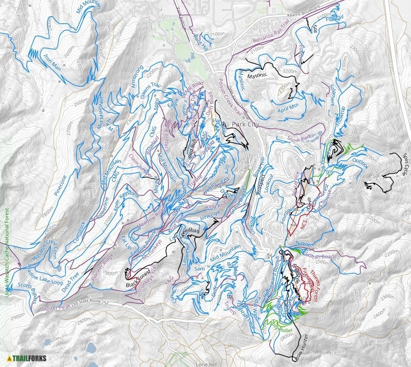
This map created using Trailforks Map Printing Interface is only a snapshot of the southern half
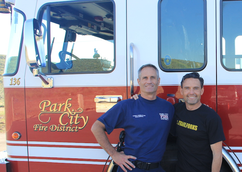
In the summer of 2011, the Captain of the PCFD, Chris Pendleton, reached out to us in hopes of using Trailforks to help their SAR efforts. As a developer who loves to write code and make maps, this was exciting. To write applications that have the potential to save lives, or at the very least, help fellow mountain bikers who are in real physical danger get down safely was pretty cool for me.
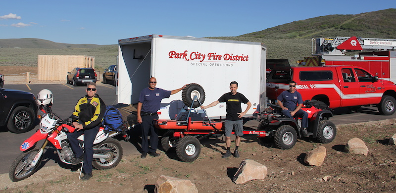
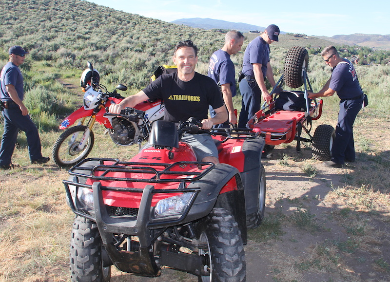
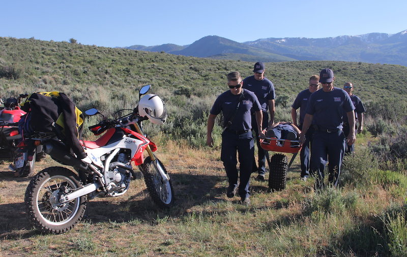
It has been more than 5 years since we deployed the SAR module, and I finally got the chance to meet up with the crew out at Trailside Park. The boys spared nothing as they filled the Happy Gilmor Trailhead with all their toys:
Full-size Fire Truck
Outfitted Dirt Bike
ATV
2 Trucks
Ambulance
They also brought a trailer with all the gear necessary to demonstrate remote rescue scenarios. To be honest, it was a bit surreal for me, a little bit like going to visit the fire station as a kid. But in this big boy version, they were using software that I had a hand in building, and it was hard to stop smiling and appear totally serious.
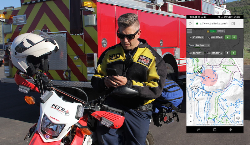
The Trailforks SAR interface shows your position with included accuracy bubble and the coordinates of the injured rider. As you travel towards the victim, the map auto-zooms in to always show where you are in relation to the target. You can reset the target if information changes and the interface will auto-reset zoom and location to include your location and target. The real power of the module comes in the accuracy of the Trailforks data and the outdoor usability of the map interface. When you have to glance down at the map in full sunlight, having accurate trails overlayed on our high contrast custom basemap makes location acquisition quick.
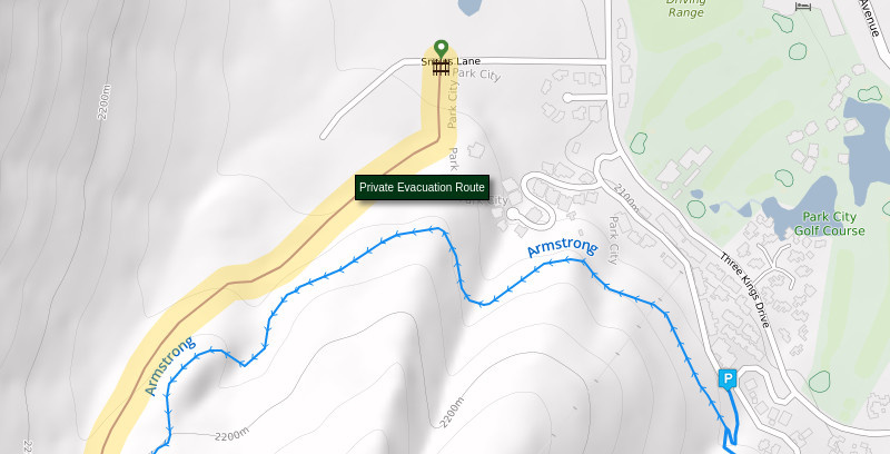
Within Trailforks you can designate a "Secondary Access Road", which paints a light purple track to signify a minor access road. Then using the "Disclaimer" field, you can add a warning when you need to designate a secondary access road as an Emergency Access Route. After discussions with some key landowners in Park City, they were OK displaying these routes, as long as we named them as "Private Evacuation Route" and added the "Gate" POI to let users know that the access road is gated and only to be used by Authorized Personnel.
In addition to the fire fighters providing me SAR demonstrations out on the trail, I got the chance to sit down with Captain Chris Pendleton for a short interview:
How long have you been doing Search and Rescue here in Park City, Utah?
The Park City Fire Service District has been active with trail rescue throughout the growth of mountain biking in the Park City area. We concentrate our efforts and response to the over 450 miles of trail that Park City provides, with Summit County Search and Rescue providing the service to the remainder of Summit County. Deer Valley and Park City Resorts also provide trail rescue on their respective properties during summer business hours. The Park City community and the Fire Service District want to ensure that its trail users enjoy our world class trail system and are proud to serve if an emergency arises.
How did you start using Trailforks for Search and Rescue in Park City?
In the past, when a 911 call would alert us with a trail rescue, the only way to locate the injured individual was by their description of the trail, or nearby landmarks. Most often, our trail users are new to the area and do not know where they are, or even what trail they are using. With over 450 miles of single track spreading throughout the Park City area, trail rescue was drawn-out and took a lot of manpower.
Trailforks filled the need to locate where the injured individual is on the trail. Until working with Trailforks, 911 Dispatch could provide the latitude and longitude of the individual, but with no relation to the trail network. Previous to Trailforks, the GPS position would only show a location dot in the middle of a mountainside – without any trail context. Now with the Trailforks SAR module, our crews type in the GPS coordinates provided by emergency dispatch (911) and the location is shown on the Trailforks SAR map. The crew location is also provided to show progress and proximity to the injured individual.
Give a quick rundown of the rescue process from the dispatch call to when your team members return to the station.
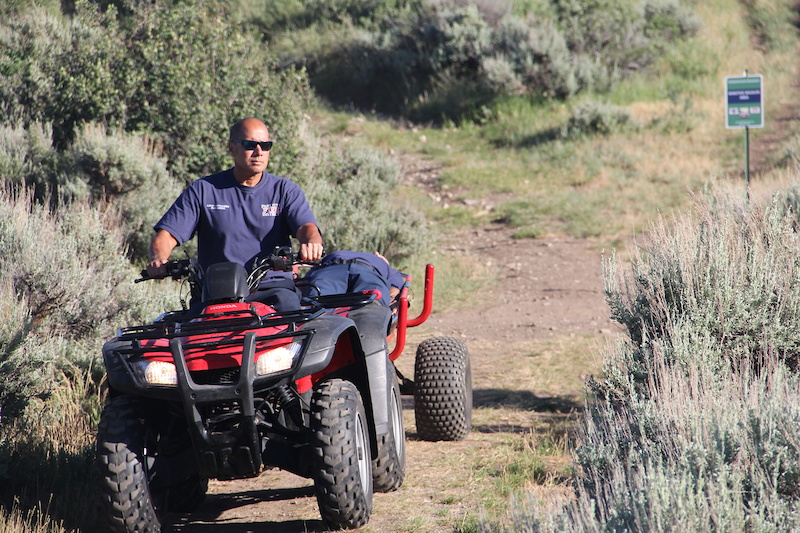
911 Dispatch receives the emergency call and dispatches our crews with the injured individual’s reported GPS coordinates. Our crews enter the given latitude and longitude into the Trailforks module, locate the individual’s position and trail and respond in a progressive mode: Trail access is accomplished by Ambulance, motorcycle, then ATV, then by foot and a rescue wheel; depending on the access.

What tools did you use before Trailforks and how has that effected response times?
Our main reference before was to use the person calling 911 Dispatch to get a location description, which was extremely variable and unreliable. There is a night and day difference in locating and responding to these type of incidents. Initial patient contact is now commonly six minutes.
What part does Trailforks play in your Search and Rescue Program?
Park City Fire District relies completely on Trailforks and 911 Dispatch information to locate the individual within the Park City Trail system.
How often would you say Trailforks is used to rescue people off the mountain?
We are seeing a large increase in trail use year after year. It is common to have several trail rescue incidents a week in the busy summer months.
It was an amazing experience to meet this crew and witness their SAR proficiency first hand. When I first walked up to the group and told them I was with Trailforks, they would pull out their phones and could launch the Trailforks SAR page without even looking. As a developer it doesn’t get much better then listening to stories of how code you wrote has been working to great effect for years. The nature of the usage, to save people injured and stranded, is icing on the cake.
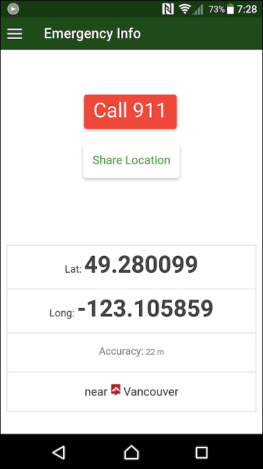
On the Trailforks application user side, there is an option to use the emergency button which will both dial out to emergency services and provide their location in large latitude/longitude numbers. On some phones, when tracking is not being used within the app, the location that the phone reports can sometimes be way off. Some phones will try to use Wifi triangulation or other means to estimate location. Using the handy emergency feature in the app, will force the phone to get try to get a good GPS fix and report your location in big and easy to read numbers. Usage of the 911 dial-out feature in the Trailforks app is not required for the SAR module to work, as they run independently. Often the PCFD relies on the 911 dispatch to provide the GPS coordinates as reported by the phone.
Having the GPS location numbers big and easily viewable is important. I didn't realize just how important until last year when I went down hard and had to "Test" the emergency features of the app myself. I overshot a table top and landed on the kicker for the next jump out on the Maple Hollow DH Trail in Draper, Utah, and had to read my GPS coordinates off of a phone covered in sweat and blood. I was luck the jumps are in an opening and the trail is old enough that the dispatch could see the trail and some possible access points on Google Earth.
Having the GPS location numbers big and easily viewable is important. I didn't realize just how important until last year when I went down hard and had to "Test" the emergency features of the app myself. I overshot a table top and landed on the kicker for the next jump out on the Maple Hollow DH Trail in Draper, Utah, and had to read my GPS coordinates off of a phone covered in sweat and blood. I was luck the jumps are in an opening and the trail is old enough that the dispatch could see the trail and some possible access points on Google Earth.
Snapshot of Trailforks App Emergency Page
My goal in writing this story is to show others how the Trailforks SAR module can be used in complicated trail systems to help find people faster. The more rescue teams that use the module and provide feedback, the more we will be able to add more SAR specific features and support. I'd like to thank the entire Park City Fire Department for rolling out the red carpet, and I look forward to working with them in the future. If you were pulled off the mountain in Park City some time in the past 5 years, chances are they used the Trailforks App to find you.
Special Thanks to the Park City Fire Department
Captain: Chris Pendleton
Captain: Leroy Fernandez
Battalion Chief: Ray Huntzinger
Firefighters: Matt Provost, Dirk Grow, Tyler Heesch, and Derek Hoke
Author Info:

Must Read This Week
Mr. Neumarker, hats off to you for making a difference. Glad you got to meet the users and hear some stories about that impact.
We have a couple of trail networks in the middle of the city (because Wellington's awesome) and I always thought that the ambulance would know the area pretty well. But one day we came across a guy who into a tree. They had no clue how to even find the park let alone closest entrance and shortest walk to get him out.
Also having the gear to get people out is awesome. At many of the parks around here people are generally helicoptered out. Without the specialist gear and people on-site meeting the target of getting someone to a hospital within an hour is a challenge at the best of time.
www.castanet.net/edition/news-story-201559-1-.htm#201559
he he
Thanks Toad.